
Make a donation
Gear up for your next adventure:
As an Amazon Associate, this site earns from qualifying purchases at no extra cost to you.
La Sagne topographic map
Click on the map to display elevation.
Make a donation
Gear up for your next adventure:
As an Amazon Associate, this site earns from qualifying purchases at no extra cost to you.
La Sagne
La Sagne liegt auf 1039 m ü. M., 6 km südsüdwestlich der Bezirkshauptstadt La Chaux-de-Fonds (Luftlinie). Das rund 2,5 km lange Strassenzeilendorf erstreckt sich im Nordosten des Hochtals Vallée des Ponts im Neuenburger Jura, westlich der Höhen von Tête de Ran und Mont Racine.
Make a donation
Gear up for your next adventure:
As an Amazon Associate, this site earns from qualifying purchases at no extra cost to you.
About this map
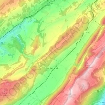
Name: La Sagne topographic map, elevation, terrain.
Location: La Sagne, Neuenburg, 2314, Schweiz (47.01371 6.75098 47.08433 6.84621)
Average elevation: 3,714 ft
Minimum elevation: 2,825 ft
Maximum elevation: 4,698 ft
Make a donation
Gear up for your next adventure:
As an Amazon Associate, this site earns from qualifying purchases at no extra cost to you.
Other topographic maps
Click on a map to view its topography, its elevation and its terrain.