Geolocate

Lanzing topographic map

Click on the map to display elevation.

About this map

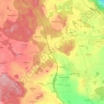
Name: Lanzing topographic map, elevation, terrain.

Location: Lanzing, Tittmoning, Landkreis Traunstein, Bayern, 84529, Deutschland (48.03491 12.70694 48.07491 12.74694)

Average elevation: 1,568 ft

Minimum elevation: 1,214 ft

Maximum elevation: 1,759 ft

Other topographic maps

Click on a map to view its topography, its elevation and its terrain.

84529

Deutschland > Bayern > Landkreis Traunstein > Tittmoning > Kay > Mühlham

Average elevation: 1,529 ft

Gear up for your next adventure:

🎒Hydration Pack - Hands‑free water reservoir for long hikes
🧥Waterproof Jacket for Hiking - Breathable and rugged rain jacket for outdoor excursions
🛌Ultralight Sleeping Bags - Compact down bags for cold nights in the wilderness
🔊Portable Camp Speaker - Music and alerts at camp
🎒Trekking Poles - Sturdy poles for balance and stability on rough terrain

As an Amazon Associate, this site earns from qualifying purchases at no extra cost to you.