
Make a donation
Gear up for your next adventure:
As an Amazon Associate, this site earns from qualifying purchases at no extra cost to you.
Grintovec topographic map
Click on the map to display elevation.
Make a donation
Gear up for your next adventure:
As an Amazon Associate, this site earns from qualifying purchases at no extra cost to you.
Grintovec
Grintovec is the highest mountain of the Kamnik–Savinja Alps, with an elevation of 2,558 metres (8,392 ft). It is a popular location for hiking, climbing and skiing. The first recorded ascent was in 1759 by the botanist Giovanni Antonio Scopoli.
Make a donation
Gear up for your next adventure:
As an Amazon Associate, this site earns from qualifying purchases at no extra cost to you.
About this map
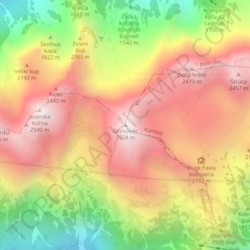
Name: Grintovec topographic map, elevation, terrain.
Location: Grintovec, Kamnik, Upravna Enota Kamnik, Slovenia (46.35708 14.53535 46.35718 14.53545)
Average elevation: 6,427 ft
Minimum elevation: 4,029 ft
Maximum elevation: 8,327 ft
Make a donation
Gear up for your next adventure:
As an Amazon Associate, this site earns from qualifying purchases at no extra cost to you.