
Maybell topographic map
Interactive map
Click on the map to display elevation.
About this map
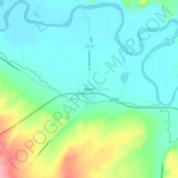
Name: Maybell topographic map, elevation, terrain.
Location: Maybell, Moffat County, Colorado, United States (40.49819 -108.10669 40.53819 -108.06669)
Average elevation: 5,988 ft
Minimum elevation: 5,879 ft
Maximum elevation: 6,286 ft
Other topographic maps
Click on a map to view its topography, its elevation and its terrain.
Craig
United States > Colorado > Moffat County
Craig, Moffat County, Colorado, 81625, United States
Average elevation: 6,309 ft
Lodore Canyon
United States > Colorado > Moffat County
Lodore Canyon, Moffat County, Colorado, United States
Average elevation: 6,775 ft