Geolocate

Teano topographic map

Click on the map to display elevation.

About this map

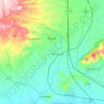
Name: Teano topographic map, elevation, terrain.

Location: Teano, Caserta, Campania, 81057, Italy (41.17671 13.98876 41.29470 14.13098)

Average elevation: 591 ft

Minimum elevation: 112 ft

Maximum elevation: 2,001 ft

Other topographic maps

Click on a map to view its topography, its elevation and its terrain.

Località Aurno

Italy > Campania > Caserta > Marcianise

Average elevation: 72 ft

Ventaroli

Italy > Campania > Caserta > Carinola

Average elevation: 512 ft

Cappelle

Italy > Campania > Caserta > Teano

Average elevation: 997 ft

Talanico

Italy > Campania > Caserta > San Felice a Cancello

Average elevation: 1,010 ft

Destra Volturno

Italy > Campania > Caserta > Castel Volturno

Average elevation: 3 ft

San Leucio-complex

Italy > Campania > Caserta > Caserta

Average elevation: 558 ft

Brezza

Italy > Campania > Caserta

Average elevation: 43 ft

Brezza

Italy > Campania > Caserta

Average elevation: 43 ft

Campo Felice

Italy > Campania > Caserta > Cellole

Average elevation: 30 ft

Gear up for your next adventure:

🗻Climbing Gear Basics - Essential gear for beginner climbers
👟Trail Running Shoes - Lightweight shoes for trail runners
🧯Portable Fire Pit - Compact fire pit for camping spots
❄️Traction Cleats - Prevent slips on icy trails during winter hikes
📦Gear Storage Bags - Organize and protect outdoor equipment

As an Amazon Associate, this site earns from qualifying purchases at no extra cost to you.