Geolocate

Stormville topographic map

Click on the map to display elevation.

About this map

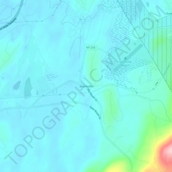
Name: Stormville topographic map, elevation, terrain.

Location: Stormville, Town of East Fishkill, Dutchess County, New York, 12582, United States (41.55037 -73.76541 41.59037 -73.72541)

Average elevation: 367 ft

Minimum elevation: 289 ft

Maximum elevation: 984 ft

Dutchess County trails, hiking, mountain biking, running and outdoor activities

Other topographic maps

Click on a map to view its topography, its elevation and its terrain.

Gear up for your next adventure:

👓Polarized Sunglasses - Outdoor sunglasses for glare reduction
🧣Merino Neck Gaiters - Multi-functional headwear for wind and sun protection
🌎3D Topographic Globes - Raised relief globes for a tactile understanding of geography
📦Gear Storage Bags - Organize and protect outdoor equipment
🏥Hiking First Aid Kits - Comprehensive medical kits for remote trail injuries

As an Amazon Associate, this site earns from qualifying purchases at no extra cost to you.