Geolocate

Garland topographic map

Click on the map to display elevation.

About this map

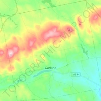
Name: Garland topographic map, elevation, terrain.

Location: Garland, Penobscot County, Maine, 04939, United States (45.00444 -69.23202 45.10720 -69.08623)

Average elevation: 505 ft

Minimum elevation: 213 ft

Maximum elevation: 1,040 ft

Penobscot County trails, hiking, mountain biking, running and outdoor activities

Other topographic maps

Click on a map to view its topography, its elevation and its terrain.

Bangor Hill

United States > Maine > Penobscot County > Orono

Average elevation: 203 ft

Hudson Hill

United States > Maine > Penobscot County > Hudson

Average elevation: 253 ft

Blackcap

United States > Maine > Penobscot County > Eddington

Average elevation: 571 ft

Sugar Island

United States > Maine > Penobscot County > Greenbush

Average elevation: 135 ft

Tiger Rips

United States > Maine > Penobscot County

Average elevation: 741 ft

State Island

United States > Maine > Penobscot County

Average elevation: 482 ft

Lincoln

United States > Maine > Penobscot County > Lincoln

Average elevation: 272 ft

Gear up for your next adventure:

🏥Hiking First Aid Kits - Comprehensive medical kits for remote trail injuries
👟Trail Running Shoes - Lightweight shoes for trail runners
🔋Rechargeable Batteries - Power up your outdoor devices
🪶Camping Sleeping Pad - Comfortable sleeping pad for backpacking
🎒Day Hiking Backpack - Lightweight backpack perfect for day trips and outdoor adventures

As an Amazon Associate, this site earns from qualifying purchases at no extra cost to you.