
Thank you for supporting this site ❤️
Make a donation
Make a donation
Gear up for your next adventure:
As an Amazon Associate, this site earns from qualifying purchases at no extra cost to you.
Vimianzo topographic map
Click on the map to display elevation.
Thank you for supporting this site ❤️
Make a donation
Make a donation
Gear up for your next adventure:
As an Amazon Associate, this site earns from qualifying purchases at no extra cost to you.
About this map
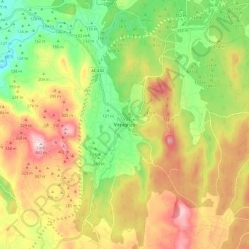
Name: Vimianzo topographic map, elevation, terrain.
Location: Vimianzo, Terra de Soneira, A Coruña, Galicia, 15126, Spain (43.07030 -9.07275 43.15030 -8.99275)
Average elevation: 728 ft
Minimum elevation: 108 ft
Maximum elevation: 1,424 ft
Thank you for supporting this site ❤️
Make a donation
Make a donation
Gear up for your next adventure:
As an Amazon Associate, this site earns from qualifying purchases at no extra cost to you.
Other topographic maps
Click on a map to view its topography, its elevation and its terrain.