Geolocate

Wingett Run topographic map

Click on the map to display elevation.

About this map

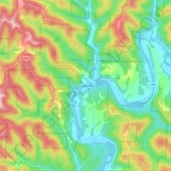
Name: Wingett Run topographic map, elevation, terrain.

Location: Wingett Run, Washington County, Ohio, United States (39.51674 -81.26317 39.55674 -81.22317)

Average elevation: 860 ft

Minimum elevation: 633 ft

Maximum elevation: 1,148 ft

Washington County trails, hiking, mountain biking, running and outdoor activities

Other topographic maps

Click on a map to view its topography, its elevation and its terrain.

Devola

United States > Ohio > Washington County

Average elevation: 715 ft

Gear up for your next adventure:

🎒Hydration Pack - Hands‑free water reservoir for long hikes
🧣Hiking Neck Gaiter - Multi‑use neck protection for outdoor weather
Solar GPS Watches - Advanced multisport watches with built-in topographic maps
🚪Portable Camp Chair - Foldable chair for comfort at camp
🔥Plasma Lighters - Windproof lighters that work in any weather condition

As an Amazon Associate, this site earns from qualifying purchases at no extra cost to you.