
Make a donation
Gear up for your next adventure:
As an Amazon Associate, this site earns from qualifying purchases at no extra cost to you.
Changsha topographic map
Click on the map to display elevation.
Make a donation
Gear up for your next adventure:
As an Amazon Associate, this site earns from qualifying purchases at no extra cost to you.
About this map
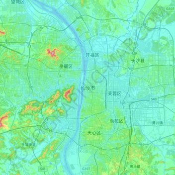
Name: Changsha topographic map, elevation, terrain.
Location: Changsha, Furong District, Changsha, Hunan, 410005, China (28.03875 112.81087 28.35875 113.13087)
Average elevation: 187 ft
Minimum elevation: 66 ft
Maximum elevation: 1,112 ft
Make a donation
Gear up for your next adventure:
As an Amazon Associate, this site earns from qualifying purchases at no extra cost to you.
Other topographic maps
Click on a map to view its topography, its elevation and its terrain.
Zhangjiajie Tianmen Mountain National Forest Park
China > Hunan > Yongding District
Average elevation: 2,562 ft
Make a donation
Gear up for your next adventure:
As an Amazon Associate, this site earns from qualifying purchases at no extra cost to you.
Make a donation
Gear up for your next adventure:
As an Amazon Associate, this site earns from qualifying purchases at no extra cost to you.
Zhangjiajie Tianmen Mountain National Forest Park
China > Hunan > Yongding District
Average elevation: 2,562 ft
Shaoshan
Shaoshan's topography is dominated by Mt. Shaofeng and the Shao and Shishi Rivers, with hills in the west giving rise to a mix of hills and plains in the east. The peak of Mount Shaofeng, 518.5 m above sea level, is the highest point whereas Liumuzhou, 48 m above sea level, is the lowest point of the whole…
Average elevation: 377 ft
Make a donation
Gear up for your next adventure:
As an Amazon Associate, this site earns from qualifying purchases at no extra cost to you.
Make a donation
Gear up for your next adventure:
As an Amazon Associate, this site earns from qualifying purchases at no extra cost to you.
Jishou
Jishou lies east of the Wuling Mountain range. About 80% of the city's terrain is low hills or low mountains. The highest elevation is 964.5 meters, at Liantaifeng (莲台峰; 蓮台峰, near the town of Aizhai (矮寨) and the lowest point is 142 meters, near the town of Hexi (simplified Chinese: 河溪镇;…
Average elevation: 1,467 ft
Make a donation
Gear up for your next adventure:
As an Amazon Associate, this site earns from qualifying purchases at no extra cost to you.
Xiangxi
Xiangxi Tujia and Miao Autonomous Prefecture is located in a low-latitude zone and has a humid subtropical monsoon climate. It is characterized by the influence of the topography of the Wuling Mountains: the winter is relatively cold, the summer temperature is high and humid, the spring and summer are wet and…
Average elevation: 1,795 ft
Make a donation
Gear up for your next adventure:
As an Amazon Associate, this site earns from qualifying purchases at no extra cost to you.
Make a donation
Gear up for your next adventure:
As an Amazon Associate, this site earns from qualifying purchases at no extra cost to you.
Make a donation
Gear up for your next adventure:
As an Amazon Associate, this site earns from qualifying purchases at no extra cost to you.
Guidong County
Guidong County belongs to the subtropical monsoon humid climate zone, no summer heat, no winter cold, warm and humid, four seasons. In spring, the southeast wind into the cold and warm air masses fronts in the territory of the confrontation hovering, insufficient light, cloudy temperature and rain. In summer,…
Average elevation: 2,910 ft
Make a donation
Gear up for your next adventure:
As an Amazon Associate, this site earns from qualifying purchases at no extra cost to you.
Make a donation
Gear up for your next adventure:
As an Amazon Associate, this site earns from qualifying purchases at no extra cost to you.
Make a donation
Gear up for your next adventure:
As an Amazon Associate, this site earns from qualifying purchases at no extra cost to you.
Make a donation
Gear up for your next adventure:
As an Amazon Associate, this site earns from qualifying purchases at no extra cost to you.
Changde
The larger prefecture-level city of Changde is adjacent to Dongting Lake to the east, the city of Yiyang to the south, Wuling and Xuefeng Mountains to the west, and Hubei province to the north. Near the border with Hubei province in Shimen county is Huping Mountain (壶瓶山), the highest peaks in Hunan…
Average elevation: 561 ft
Make a donation
Gear up for your next adventure:
As an Amazon Associate, this site earns from qualifying purchases at no extra cost to you.
Zhijiang Dong Autonomous County
China > Hunan > Zhijiang Dong Autonomous County
Average elevation: 1,375 ft
Make a donation
Gear up for your next adventure:
As an Amazon Associate, this site earns from qualifying purchases at no extra cost to you.