Geolocate

Vayala topographic map

Click on the map to display elevation.

About this map

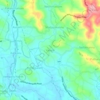
Name: Vayala topographic map, elevation, terrain.

Location: Vayala, Meenachil, Kottayam, Kerala, 686587, India (9.70715 76.55488 9.74715 76.59488)

Average elevation: 135 ft

Minimum elevation: 20 ft

Maximum elevation: 449 ft

Other topographic maps

Click on a map to view its topography, its elevation and its terrain.

Melukavu

India > Kerala > Meenachil > Melukavumattom

Average elevation: 1,965 ft

Poonjar-Thekkekara

India > Kerala > Meenachil > Vazhikadavu

Average elevation: 1,234 ft

Chovoor

India > Kerala > Meenachil

Average elevation: 1,073 ft

Gear up for your next adventure:

🧼Biodegradable Camping Soap - Eco‑friendly soap for outdoor hygiene
Solar GPS Watches - Advanced multisport watches with built-in topographic maps
🪶Camping Sleeping Pad - Comfortable sleeping pad for backpacking
🧤Hiking Gloves - Protective gloves for rugged trails
🌡️Handheld Weather Meters - Measure wind, temp, and pressure for safe mountain travel

As an Amazon Associate, this site earns from qualifying purchases at no extra cost to you.