
Make a donation
Gear up for your next adventure:
As an Amazon Associate, this site earns from qualifying purchases at no extra cost to you.
Bahri topographic map
Click on the map to display elevation.
Make a donation
Gear up for your next adventure:
As an Amazon Associate, this site earns from qualifying purchases at no extra cost to you.
About this map
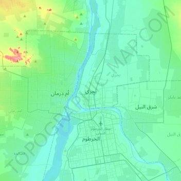
Name: Bahri topographic map, elevation, terrain.
Location: Bahri, Al Khartum State, 13311, Sudan (15.48785 32.37458 15.80785 32.69458)
Average elevation: 1,283 ft
Minimum elevation: 1,220 ft
Maximum elevation: 1,627 ft
Make a donation
Gear up for your next adventure:
As an Amazon Associate, this site earns from qualifying purchases at no extra cost to you.
Other topographic maps
Click on a map to view its topography, its elevation and its terrain.
Khartoum
In 1821, Khartoum was established 24 km (15 mi) north of the ancient city of Soba, by Isma'il Kamil Pasha, the third son of Egypt's ruler, Muhammad Ali Pasha, who had just incorporated Sudan into his realm. Originally, Khartoum served as an outpost for the Egyptian Army. Egypt shifted the seat of the colonial…
Average elevation: 1,260 ft
Make a donation
Gear up for your next adventure:
As an Amazon Associate, this site earns from qualifying purchases at no extra cost to you.