
Make a donation
Gear up for your next adventure:
As an Amazon Associate, this site earns from qualifying purchases at no extra cost to you.
Langerwehe topographic map
Click on the map to display elevation.
Make a donation
Gear up for your next adventure:
As an Amazon Associate, this site earns from qualifying purchases at no extra cost to you.
About this map
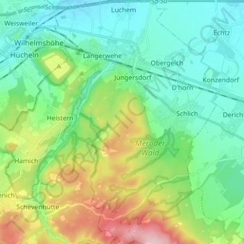
Name: Langerwehe topographic map, elevation, terrain.
Location: Langerwehe, Kreis Düren, North Rhine-Westphalia, 52379, Germany (50.75648 6.29851 50.83550 6.41830)
Average elevation: 600 ft
Minimum elevation: 361 ft
Maximum elevation: 1,214 ft
Make a donation
Gear up for your next adventure:
As an Amazon Associate, this site earns from qualifying purchases at no extra cost to you.
Other topographic maps
Click on a map to view its topography, its elevation and its terrain.
In der Frack
Germany > North Rhine-Westphalia > Kreis Düren > Linnich > Welz
Average elevation: 256 ft
Make a donation
Gear up for your next adventure:
As an Amazon Associate, this site earns from qualifying purchases at no extra cost to you.