
Make a donation
Gear up for your next adventure:
As an Amazon Associate, this site earns from qualifying purchases at no extra cost to you.
California topographic map
Click on the map to display elevation.
Make a donation
Gear up for your next adventure:
As an Amazon Associate, this site earns from qualifying purchases at no extra cost to you.
About this map
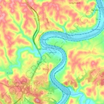
Name: California topographic map, elevation, terrain.
Location: California, Washington County, Pennsylvania, United States (40.02631 -79.94694 40.10572 -79.87927)
Average elevation: 1,037 ft
Minimum elevation: 755 ft
Maximum elevation: 1,339 ft
Washington County trails, hiking, mountain biking, running and outdoor activities
Make a donation
Gear up for your next adventure:
As an Amazon Associate, this site earns from qualifying purchases at no extra cost to you.
Other topographic maps
Click on a map to view its topography, its elevation and its terrain.
Cowden
United States > Pennsylvania > Washington County > Cecil Township > Cecil
Average elevation: 1,135 ft
Atlasburg
United States > Pennsylvania > Washington County > Smith Township
Average elevation: 1,165 ft
Malden Place
United States > Pennsylvania > Washington County > Centerville
Average elevation: 1,053 ft
Millsboro
United States > Pennsylvania > Washington County > East Bethlehem Township
Average elevation: 1,010 ft
Make a donation
Gear up for your next adventure:
As an Amazon Associate, this site earns from qualifying purchases at no extra cost to you.
South Strabane
United States > Pennsylvania > Washington County > South Strabane Township
Average elevation: 1,237 ft
Vance
United States > Pennsylvania > Washington County > South Strabane Township
Average elevation: 1,217 ft
Langeloth
United States > Pennsylvania > Washington County > Smith Township
Average elevation: 1,155 ft
Make a donation
Gear up for your next adventure:
As an Amazon Associate, this site earns from qualifying purchases at no extra cost to you.
Lover
United States > Pennsylvania > Washington County > Fallowfield Township
Average elevation: 1,175 ft
Munntown
United States > Pennsylvania > Washington County > Nottingham Township
Average elevation: 1,152 ft
Enterprise
United States > Pennsylvania > Washington County > South Strabane Township
Average elevation: 1,096 ft
Make a donation
Gear up for your next adventure:
As an Amazon Associate, this site earns from qualifying purchases at no extra cost to you.
Linden
United States > Pennsylvania > Washington County > North Strabane Township
Average elevation: 1,086 ft
Victory Hills
United States > Pennsylvania > Washington County > Carroll Township
Average elevation: 1,004 ft
Chambers Mill
United States > Pennsylvania > Washington County > South Franklin Township
Average elevation: 1,201 ft
Blainsburg
United States > Pennsylvania > Washington County > West Brownsville
Average elevation: 978 ft
Make a donation
Gear up for your next adventure:
As an Amazon Associate, this site earns from qualifying purchases at no extra cost to you.
Mount Wheeler
United States > Pennsylvania > Washington County > North Franklin Township
Average elevation: 1,253 ft
Make a donation
Gear up for your next adventure:
As an Amazon Associate, this site earns from qualifying purchases at no extra cost to you.
Shire Oaks
United States > Pennsylvania > Washington County > Union Township > Shire Oaks
Average elevation: 968 ft