
Crooksville topographic map
Interactive map
Click on the map to display elevation.
About this map
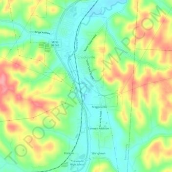
Name: Crooksville topographic map, elevation, terrain.
Location: Crooksville, Perry County, Ohio, United States (39.74069 -82.10996 39.78290 -82.08197)
Average elevation: 856 ft
Minimum elevation: 722 ft
Maximum elevation: 1,047 ft
Other topographic maps
Click on a map to view its topography, its elevation and its terrain.
Glenford
United States > Ohio > Perry County
Glenford, Perry County, Ohio, United States
Average elevation: 896 ft
Portersville
United States > Ohio > Perry County
Portersville, Perry County, Ohio, United States
Average elevation: 991 ft
Corning
United States > Ohio > Perry County
Corning, Perry County, Ohio, United States
Average elevation: 833 ft
Shawnee
United States > Ohio > Perry County
Shawnee, Perry County, Ohio, 43782, United States
Average elevation: 912 ft
New Straitsville
United States > Ohio > Perry County
New Straitsville, Perry County, Ohio, United States
Average elevation: 912 ft
Mount Perry
United States > Ohio > Perry County
Mount Perry, Perry County, Ohio, 43760, United States
Average elevation: 896 ft
Glass Rock
United States > Ohio > Perry County
Glass Rock, Perry County, Ohio, 43739, United States
Average elevation: 928 ft
New Lexington
United States > Ohio > Perry County
New Lexington, Perry County, Ohio, United States
Average elevation: 915 ft