Geolocate

Berneray topographic map

Click on the map to display elevation.

About this map

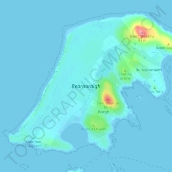
Name: Berneray topographic map, elevation, terrain.

Location: Berneray, Rushgarry, Western Isles, Scotland, United Kingdom (57.70049 -7.22874 57.73893 -7.14385)

Average elevation: 20 ft

Minimum elevation: -3 ft

Maximum elevation: 299 ft

Gear up for your next adventure:

🌡️Portable Weather Meter - Track weather conditions on the trail
🛡️Bear Spray Outdoor - Protection in bear country hikes
🎒Outdoor Daypacks - Lightweight backpacks designed for carrying maps and essential gear
📷Action Cameras - Rugged cameras to document your journeys across rugged terrain
🪑Ultralight Camp Chairs - Portable seating for resting after a long day of mapping

As an Amazon Associate, this site earns from qualifying purchases at no extra cost to you.