Geolocate

Nono topographic map

Click on the map to display elevation.

About this map

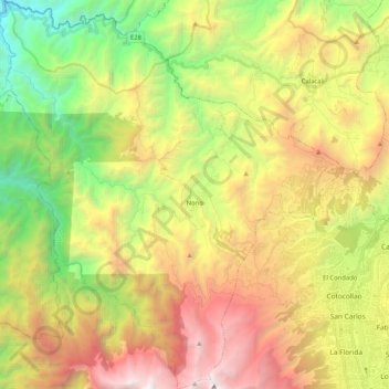
Name: Nono topographic map, elevation, terrain.

Location: Nono, Quito Canton, Pichincha, Ecuador (-0.16422 -78.68081 0.04177 -78.49739)

Average elevation: 9,432 ft

Minimum elevation: 4,751 ft

Maximum elevation: 15,299 ft

Other topographic maps

Click on a map to view its topography, its elevation and its terrain.

San Martin

Ecuador > Pichincha > Quito Canton > Nono

Average elevation: 9,163 ft

Barrio Nuevo

Ecuador > Pichincha > Quito Canton > Nanegal

Average elevation: 5,230 ft

Nayón

Ecuador > Pichincha > Quito Canton

Average elevation: 8,520 ft

Santa Rosa

Ecuador > Pichincha > Quito Canton > Puembo

Average elevation: 7,900 ft

2 Puentes

Ecuador > Pichincha > Quito Canton > Quito

Average elevation: 9,751 ft

Puéllaro

Ecuador > Pichincha > Quito Canton > Puéllaro

Average elevation: 7,011 ft

La Delicia

Ecuador > Pichincha > Quito Canton > San Felipe

Average elevation: 8,907 ft

Tanda

Ecuador > Pichincha > Quito Canton

Average elevation: 8,176 ft

Gear up for your next adventure:

🪑Portable Camp Table - Compact table for campsite meals
🧤Hiking Gloves - Protective gloves for rugged trails
🔭Compact Binoculars - HD vision for scouting terrain and identifying distant landmarks
🪶Trail Camera - Capture wildlife on your hikes
🧭Outdoor Navigation Book - Learn advanced navigation skills

As an Amazon Associate, this site earns from qualifying purchases at no extra cost to you.