Geolocate

Tanda topographic map

Click on the map to display elevation.

About this map

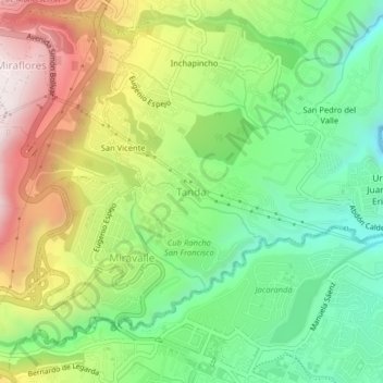
Name: Tanda topographic map, elevation, terrain.

Location: Tanda, Nayon, Quito Canton, Pichincha, 170157, Ecuador (-0.20064 -78.45815 -0.16064 -78.41815)

Average elevation: 8,176 ft

Minimum elevation: 7,129 ft

Maximum elevation: 9,701 ft

Other topographic maps

Click on a map to view its topography, its elevation and its terrain.

La Magdalena

Ecuador > Pichincha > Quito Canton > Quito

Average elevation: 9,334 ft

Nono

Ecuador > Pichincha > Quito Canton

Average elevation: 9,432 ft

Tumbaco

Ecuador > Pichincha > Quito Canton

Average elevation: 8,199 ft

Amaguaña

Ecuador > Pichincha > Quito Canton

Average elevation: 9,501 ft

Quitumbe

Ecuador > Pichincha > Quito Canton > Quito

Average elevation: 9,793 ft

Gear up for your next adventure:

🗻Climbing Gear Basics - Essential gear for beginner climbers
🚑Emergency Bivvies - Heat-reflective sleeping bags for survival situations
🩹Survival Bandages - High‑quality bandages for emergencies
❄️Traction Cleats - Prevent slips on icy trails during winter hikes
Backpacking Tent - Lightweight and durable tent for multi‑day hikes

As an Amazon Associate, this site earns from qualifying purchases at no extra cost to you.