Geolocate

Tandayapa topographic map

Click on the map to display elevation.

About this map

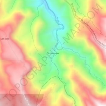
Name: Tandayapa topographic map, elevation, terrain.

Location: Tandayapa, Nanegalito, Quito Canton, Pichincha, Ecuador (-0.01696 -78.69583 0.02304 -78.65583)

Average elevation: 6,467 ft

Minimum elevation: 5,016 ft

Maximum elevation: 7,740 ft

Other topographic maps

Click on a map to view its topography, its elevation and its terrain.

Tumbaco

Ecuador > Pichincha > Quito Canton

Average elevation: 8,199 ft

La Floresta

Ecuador > Pichincha > Quito Canton

Average elevation: 9,091 ft

Guangopolo

Ecuador > Pichincha > Quito Canton

Average elevation: 8,189 ft

Nono

Ecuador > Pichincha > Quito Canton

Average elevation: 9,432 ft

Calacali

Ecuador > Pichincha > Quito Canton

Average elevation: 7,707 ft

Gear up for your next adventure:

Backpacking Tent - Lightweight and durable tent for multi‑day hikes
📶Satellite Messenger - Communication device off‑grid
📦Gear Storage Bags - Organize and protect outdoor equipment
🧭GPS Watch Accessories - Bands and chargers for GPS watches
🦶Hiking Gaiters - Keep debris and water out of your boots

As an Amazon Associate, this site earns from qualifying purchases at no extra cost to you.