
Make a donation
Gear up for your next adventure:
As an Amazon Associate, this site earns from qualifying purchases at no extra cost to you.
Ullúm topographic map
Click on the map to display elevation.
Make a donation
Gear up for your next adventure:
As an Amazon Associate, this site earns from qualifying purchases at no extra cost to you.
About this map
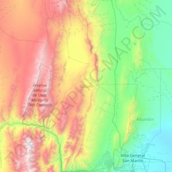
Name: Ullúm topographic map, elevation, terrain.
Location: Ullúm, San Juan, 5414, Argentina (-31.52118 -69.25806 -30.53520 -68.48550)
Average elevation: 5,381 ft
Minimum elevation: 1,906 ft
Maximum elevation: 13,156 ft
Make a donation
Gear up for your next adventure:
As an Amazon Associate, this site earns from qualifying purchases at no extra cost to you.
Other topographic maps
Click on a map to view its topography, its elevation and its terrain.
San Juan
San Juan is ranked second among the wine-producing provinces of Argentina. It has a cultivated area of 116,700 acres at altitudes of between 1,970 (601m) and 4,590 feet (1399m) above sea level. This region specializes in Syrah, Malbec, Cabernet Sauvignon, Bonarda, Chardonnay and Torrontés. Because of this…
Average elevation: 2,277 ft
Make a donation
Gear up for your next adventure:
As an Amazon Associate, this site earns from qualifying purchases at no extra cost to you.
Make a donation
Gear up for your next adventure:
As an Amazon Associate, this site earns from qualifying purchases at no extra cost to you.