
Chester topographic map
Click on the map to display elevation.
Chester
According to the United States Census Bureau, the town has a total area of 26.1 square miles (67.7 km2), of which 26.0 square miles (67.4 km2) are land and 0.12 square miles (0.3 km2), or 0.43%, are water. The highest point in town is found on an unnamed hill west of Bell Hill and northwest of Harantis Lake; it has two knobs of almost equal elevation of at least 635 feet (194 m), according to the most recent (2011–2012) USGS 7.5-minute topographical map. The Exeter River rises in Chester. The area of Chester drained by the Exeter and its tributary Towle Brook lies within the Piscataqua River (Coastal) watershed, while the western edge of town drains west toward Massabesic Lake and is in the Merrimack River watershed.
About this map
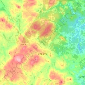
Name: Chester topographic map, elevation, terrain.
Average elevation: 367 ft
Minimum elevation: 148 ft
Maximum elevation: 650 ft
Rockingham County trails, hiking, mountain biking, running and outdoor activities
Other topographic maps
Click on a map to view its topography, its elevation and its terrain.
South Beacon Shoal
United States > New Hampshire > Rockingham County > Portsmouth
Average elevation: 13 ft
Hampton River
United States > New Hampshire > Rockingham County > Hampton Falls
Average elevation: 3 ft
Providence Hill
United States > New Hampshire > Rockingham County > Atkinson
Average elevation: 236 ft
Salem Depot
United States > New Hampshire > Rockingham County > Salem > Salem Depot
Average elevation: 164 ft
Rye Beach Village District
United States > New Hampshire > Rockingham County > Rye Beach Village District
Average elevation: 23 ft