
Make a donation
Gear up for your next adventure:
As an Amazon Associate, this site earns from qualifying purchases at no extra cost to you.
Isla Navarino topographic map
Click on the map to display elevation.
Make a donation
Gear up for your next adventure:
As an Amazon Associate, this site earns from qualifying purchases at no extra cost to you.
About this map
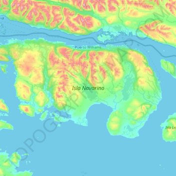
Name: Isla Navarino topographic map, elevation, terrain.
Average elevation: 564 ft
Minimum elevation: 0 ft
Maximum elevation: 4,400 ft
Make a donation
Gear up for your next adventure:
As an Amazon Associate, this site earns from qualifying purchases at no extra cost to you.
Other topographic maps
Click on a map to view its topography, its elevation and its terrain.
Cerro Castillo
Chile > Region of Magallanes and Chilean Antarctica > Provincia de Tierra del Fuego > Timaukel
Average elevation: 2,671 ft
Peak
Chile > Region of Magallanes and Chilean Antarctica > Provincia de Magallanes > Punta Arenas
Average elevation: 157 ft
Volcán Lautaro
Chile > Region of Magallanes and Chilean Antarctica > Provincia de Última Esperanza > Puerto Natales
Average elevation: 9,934 ft