
Thank you for supporting this site ❤️
Make a donation
Make a donation
Gear up for your next adventure:
As an Amazon Associate, this site earns from qualifying purchases at no extra cost to you.
Altlöbau topographic map
Click on the map to display elevation.
Thank you for supporting this site ❤️
Make a donation
Make a donation
Gear up for your next adventure:
As an Amazon Associate, this site earns from qualifying purchases at no extra cost to you.
About this map
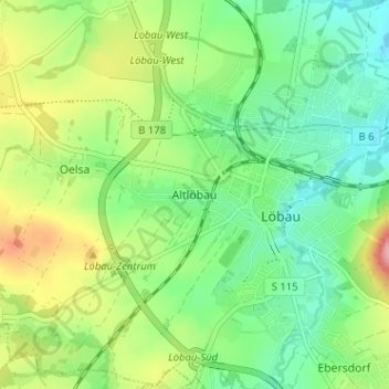
Name: Altlöbau topographic map, elevation, terrain.
Location: Altlöbau, Löbau, Görlitz, Sachsen, 02708, Deutschland (51.07694 14.63506 51.11694 14.67506)
Average elevation: 928 ft
Minimum elevation: 751 ft
Maximum elevation: 1,257 ft
Thank you for supporting this site ❤️
Make a donation
Make a donation
Gear up for your next adventure:
As an Amazon Associate, this site earns from qualifying purchases at no extra cost to you.