
Morehead topographic map
Click on the map to display elevation.
About this map
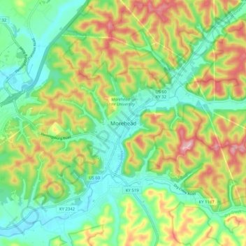
Name: Morehead topographic map, elevation, terrain.
Location: Morehead, Rowan County, Kentucky, 40351, United States (38.14397 -83.47268 38.22397 -83.39268)
Average elevation: 932 ft
Minimum elevation: 676 ft
Maximum elevation: 1,355 ft
Rowan County trails, hiking, mountain biking, running and outdoor activities
Other topographic maps
Click on a map to view its topography, its elevation and its terrain.
Morehead
United States > Kentucky > Rowan County
Morehead is in the foothills of the Appalachian Mountains. The topography of the area represents a mixture of the Highland Rim and the western border of the Eastern Kentucky Coalfield. The highest elevation in the county is Limestone Knob (1435 ft), situated approximately 3 miles southwest of Morehead. The…
Average elevation: 942 ft