
Franklin topographic map
Click on the map to display elevation.
Franklin
Franklin is located at 35°10′52″N 83°22′54″W / 35.18111°N 83.38167°W / 35.18111; -83.38167 (35.181144, -83.381685). The elevation of Franklin is 2119 ft.
About this map
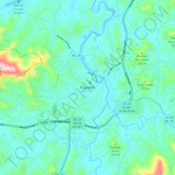
Name: Franklin topographic map, elevation, terrain.
Location: Franklin, Macon County, North Carolina, 28734, United States (35.14232 -83.42154 35.22232 -83.34154)
Average elevation: 2,182 ft
Minimum elevation: 1,962 ft
Maximum elevation: 3,271 ft
Macon County trails, hiking, mountain biking, running and outdoor activities
Other topographic maps
Click on a map to view its topography, its elevation and its terrain.
Little Tennessee River
United States > North Carolina > Macon County > Franklin > East Franklin
Average elevation: 2,103 ft