Geolocate

Chulluni topographic map

Click on the map to display elevation.

About this map

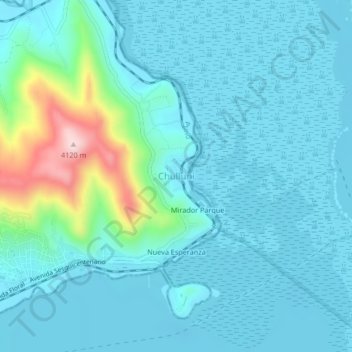
Name: Chulluni topographic map, elevation, terrain.

Location: Chulluni, Puno, 21000, Perú (-15.83350 -70.01391 -15.79350 -69.97391)

Average elevation: 12,644 ft

Minimum elevation: 12,490 ft

Maximum elevation: 13,520 ft

Other topographic maps

Click on a map to view its topography, its elevation and its terrain.

Ciudad de los niños

Perú > Puno > Puno

Average elevation: 12,733 ft

Gear up for your next adventure:

🖼️Topo Map Wall Art - Decorative topographic prints of famous peaks and regions
🩳Quick‑Dry Hiking Shorts - Comfortable and quick‑dry shorts for summer hiking
🔦Compact Flashlight - Reliable flashlight for emergencies
🪶Fire Starter Kit - Reliable fire starter for survival and camping
🪶LED Camping Lantern - Bright lantern for camp lighting

As an Amazon Associate, this site earns from qualifying purchases at no extra cost to you.