Geolocate

Kalamansig topographic map

Click on the map to display elevation.

About this map

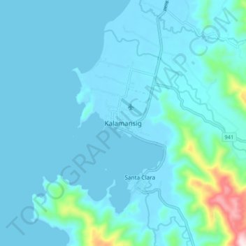
Name: Kalamansig topographic map, elevation, terrain.

Location: Kalamansig, Sultan Kudarat, Soccsksargen, 9808, Philippines (6.51458 124.01060 6.59458 124.09060)

Average elevation: 161 ft

Minimum elevation: -3 ft

Maximum elevation: 1,742 ft

Other topographic maps

Click on a map to view its topography, its elevation and its terrain.

Kabulnan River

Philippines > Sultan Kudarat

Average elevation: 1,939 ft

Gear up for your next adventure:

🗺️Topographic Maps - Detailed topo maps for hiking, exploring and outdoor navigation
🧦Hiking Socks - Comfortable socks to prevent blisters on long hikes
🥾Hiking Shoes - Durable and comfortable shoes for trail hiking
🪑Ultralight Camp Chairs - Portable seating for resting after a long day of mapping
Backpacking Tent - Lightweight and durable tent for multi‑day hikes

As an Amazon Associate, this site earns from qualifying purchases at no extra cost to you.