
Cedar Grove topographic map
Click on the map to display elevation.
Cedar Grove
The township is located between the First and Second Watchung Mountains. The center of the township is in a valley that is about 280 feet (85 m) above sea level; however, many sections of Cedar Grove are well above 400 feet (120 m), including the Park Ridge Estates, the abandoned Essex County Hospital Center, and the eastern, southeastern and southern sections of Cedar Grove. Cedar Grove's highest point is on hilltop, where elevations reach 600 feet (180 m) and above. Cedar Grove is located approximately 12 miles (19 km) west of Midtown Manhattan and 4 miles (6.4 km) northwest of Newark.
About this map
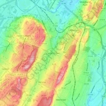
Name: Cedar Grove topographic map, elevation, terrain.
Location: Cedar Grove, Essex County, New Jersey, 07009, United States (40.81177 -74.26904 40.89177 -74.18904)
Average elevation: 354 ft
Minimum elevation: 121 ft
Maximum elevation: 692 ft
Essex County trails, hiking, mountain biking, running and outdoor activities