
Make a donation
Gear up for your next adventure:
As an Amazon Associate, this site earns from qualifying purchases at no extra cost to you.
Grand Wintersberg topographic map
Click on the map to display elevation.
Make a donation
Gear up for your next adventure:
As an Amazon Associate, this site earns from qualifying purchases at no extra cost to you.
Grand Wintersberg
L'accès pédestre est facile, via une route forestière à la circulation tolérée de jour, partant de l'usine Celtic et montant jusqu'au col forestier de la Liese (à 513 mètres d'altitude, au nord, abritant le chalet du Club vosgien de Niederbronn). Autrement, l'ascension en partance de la vallée, plus traditionnelle elle, s'effectue depuis Niederbronn, en empruntant le sentier balisé du rectangle rouge (GR53) : sa montée en forêt permet d'accéder au camp celtique du Ziegenberg.
Make a donation
Gear up for your next adventure:
As an Amazon Associate, this site earns from qualifying purchases at no extra cost to you.
About this map
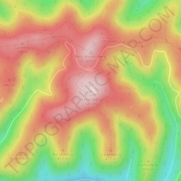
Name: Grand Wintersberg topographic map, elevation, terrain.
Average elevation: 1,375 ft
Minimum elevation: 679 ft
Maximum elevation: 1,890 ft
Make a donation
Gear up for your next adventure:
As an Amazon Associate, this site earns from qualifying purchases at no extra cost to you.
Other topographic maps
Click on a map to view its topography, its elevation and its terrain.