
Make a donation
Gear up for your next adventure:
As an Amazon Associate, this site earns from qualifying purchases at no extra cost to you.
La Fueva topographic map
Click on the map to display elevation.
Make a donation
Gear up for your next adventure:
As an Amazon Associate, this site earns from qualifying purchases at no extra cost to you.
About this map
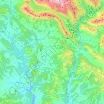
Name: La Fueva topographic map, elevation, terrain.
Location: La Fueva, Sobrarbe, Huesca, Aragón, España (42.23858 0.15990 42.51197 0.37921)
Average elevation: 3,028 ft
Minimum elevation: 1,450 ft
Maximum elevation: 9,455 ft
Make a donation
Gear up for your next adventure:
As an Amazon Associate, this site earns from qualifying purchases at no extra cost to you.
Other topographic maps
Click on a map to view its topography, its elevation and its terrain.
Make a donation
Gear up for your next adventure:
As an Amazon Associate, this site earns from qualifying purchases at no extra cost to you.
Monte Perdido
Monte Perdido es el macizo calcáreo más alto de Europa. Se encuentra situado dentro de la vertiente sur del Pirineo central, al norte de la provincia de Huesca, en el parque nacional de Ordesa y Monte Perdido, en la comunidad autónoma de Aragón (España). Su pico más elevado es el Monte Perdido, con una…
Average elevation: 9,206 ft
Las Bellostas
Se sitúa a 17 km de Aínsa y a una altitud de 1.110 metros cerrando el valle del río Vero y entre éste y el río Balcés.
Average elevation: 3,533 ft
Make a donation
Gear up for your next adventure:
As an Amazon Associate, this site earns from qualifying purchases at no extra cost to you.
Cilindro de Marboré
El pico Cilindro, también llamado Cilindro de Marboré, es un pico de 3328 m de altitud del macizo de Monte Perdido, dentro de la cordillera del Pirineo y que se sitúa íntegramente en España (Valle de Ordesa), pero muy cerca de la frontera con Francia (Circo de Gavarnie) con la que limita el Pico Marboré,…
Average elevation: 9,350 ft
Make a donation
Gear up for your next adventure:
As an Amazon Associate, this site earns from qualifying purchases at no extra cost to you.
Make a donation
Gear up for your next adventure:
As an Amazon Associate, this site earns from qualifying purchases at no extra cost to you.
Cilindro de Marboré
El pico Cilindro, también llamado Cilindro de Marboré, es un pico de 3328 m de altitud del macizo de Monte Perdido, dentro de la cordillera del Pirineo y que se sitúa íntegramente en España (Valle de Ordesa), pero muy cerca de la frontera con Francia (Circo de Gavarnie) con la que limita el Pico Marboré,…
Average elevation: 9,350 ft
Make a donation
Gear up for your next adventure:
As an Amazon Associate, this site earns from qualifying purchases at no extra cost to you.
Olsón
Entre las cuencas del Cinca y el Vero, en un valle muy abrupto, a 686 m de altitud en las estribaciones de la sierra de San Benedet, en la subcomarca del Viello Sobrarbe que se extiende entre al suroeste de la comarca de Sobrarbe, se encuentra este pequeño núcleo rural que está dividido en cuatro barrios,…
Average elevation: 2,198 ft
Make a donation
Gear up for your next adventure:
As an Amazon Associate, this site earns from qualifying purchases at no extra cost to you.
Make a donation
Gear up for your next adventure:
As an Amazon Associate, this site earns from qualifying purchases at no extra cost to you.
Make a donation
Gear up for your next adventure:
As an Amazon Associate, this site earns from qualifying purchases at no extra cost to you.