
Make a donation
Gear up for your next adventure:
As an Amazon Associate, this site earns from qualifying purchases at no extra cost to you.
Estépar topographic map
Click on the map to display elevation.
Make a donation
Gear up for your next adventure:
As an Amazon Associate, this site earns from qualifying purchases at no extra cost to you.
Estépar
El relieve del municipio está caracterizado por la típica llanura castellana por la que discurre el río Arlanzón y su afluente el río Hormazuela. Cuenta con algunas elevaciones en su territorio, siendo su máxima altitud el cerro Quintanilla (960 metros). El pueblo se alza a 812 metros sobre el nivel del mar, entre el Monte de Estépar (854 m) y la ribera del río Arlanzón. La altitud del municipio oscila entre los 960 metros y los 790 metros.
Make a donation
Gear up for your next adventure:
As an Amazon Associate, this site earns from qualifying purchases at no extra cost to you.
About this map
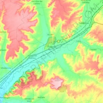
Name: Estépar topographic map, elevation, terrain.
Location: Estépar, Burgos, Castilla y León, España (42.19857 -3.96497 42.34175 -3.78857)
Average elevation: 2,822 ft
Minimum elevation: 2,556 ft
Maximum elevation: 3,143 ft
Make a donation
Gear up for your next adventure:
As an Amazon Associate, this site earns from qualifying purchases at no extra cost to you.
Other topographic maps
Click on a map to view its topography, its elevation and its terrain.
Make a donation
Gear up for your next adventure:
As an Amazon Associate, this site earns from qualifying purchases at no extra cost to you.