
Thank you for supporting this site ❤️
Make a donation
Make a donation
Gear up for your next adventure:
As an Amazon Associate, this site earns from qualifying purchases at no extra cost to you.
Minera topographic map
Click on the map to display elevation.
Thank you for supporting this site ❤️
Make a donation
Make a donation
Gear up for your next adventure:
As an Amazon Associate, this site earns from qualifying purchases at no extra cost to you.
About this map
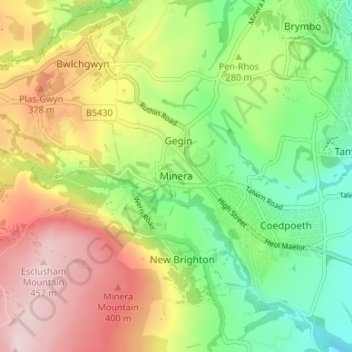
Name: Minera topographic map, elevation, terrain.
Location: Minera, Wrexham, Wales, LL11 3YU, United Kingdom (53.03958 -3.10472 53.07958 -3.06472)
Average elevation: 912 ft
Minimum elevation: 453 ft
Maximum elevation: 1,496 ft
Thank you for supporting this site ❤️
Make a donation
Make a donation
Gear up for your next adventure:
As an Amazon Associate, this site earns from qualifying purchases at no extra cost to you.