Geolocate

Gurugram topographic map

Click on the map to display elevation.

About this map

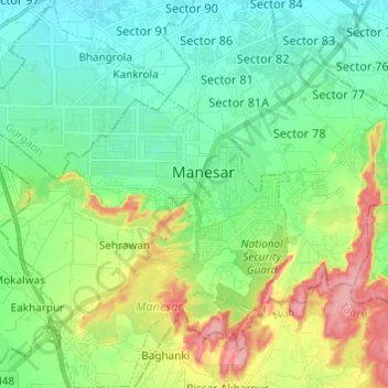
Name: Gurugram topographic map, elevation, terrain.

Location: Manesar, Gurugram, Haryana, India (28.30234 76.86961 28.40909 76.96717)

Average elevation: 850 ft

Minimum elevation: 728 ft

Maximum elevation: 1,122 ft

Other topographic maps

Click on a map to view its topography, its elevation and its terrain.

Ghamroj

India > Haryana > Gurugram

Average elevation: 804 ft

Sohna

India > Haryana > Gurugram

Average elevation: 751 ft

Gear up for your next adventure:

🪶Wildlife Field Guides - Learn animal tracking and species ID
🔌Solar Panel Charger - Charge gear sustainably outdoors
👟Men's Trail Runners - Lightweight footwear for fast-paced exploration and light hiking
📦Gear Storage Bags - Organize and protect outdoor equipment
🧦Merino Wool Socks - Moisture-wicking, blister-preventing socks for long treks

As an Amazon Associate, this site earns from qualifying purchases at no extra cost to you.