
Harbor topographic map
Click on the map to display elevation.
About this map
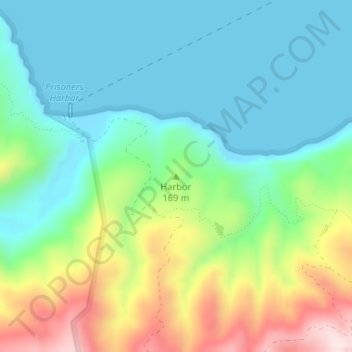
Name: Harbor topographic map, elevation, terrain.
Location: Harbor, Santa Barbara County, California, United States (34.01488 -119.67456 34.01498 -119.67446)
Average elevation: 387 ft
Minimum elevation: 0 ft
Maximum elevation: 1,296 ft
Santa Barbara County trails, hiking, mountain biking, running and outdoor activities
Other topographic maps
Click on a map to view its topography, its elevation and its terrain.
Mission Canyon
United States > California > Santa Barbara County
The approximate center of Mission Canyon is located at 34°26′59″N 119°42′59″W / 34.44972°N 119.71639°W / 34.44972; -119.71639 (34.449797, -119.716315). Situated along the southern facing slopes of the Santa Ynez Mountains, Mission Canyon measures some 1,122 acres comprising an estimated…
Average elevation: 653 ft
Solvang
United States > California > Santa Barbara County
Solvang is located at 34°35′38″N 120°8′23″W / 34.59389°N 120.13972°W / 34.59389; -120.13972. At an elevation of 505 ft (154 m), it lies in the Santa Ynez Valley some 46 miles (74 km) north-west of Santa Barbara and about 15 miles (24 km) north of the Pacific coast. According to the United…
Average elevation: 636 ft