
North District topographic map
Interactive map
Click on the map to display elevation.
About this map
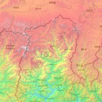
Name: North District topographic map, elevation, terrain.
Location: North District, North Sikkim District, Sikkim, India (27.02667 87.86000 28.30667 89.14000)
Average elevation: 12,605 ft
Minimum elevation: 883 ft
Maximum elevation: 27,851 ft
Other topographic maps
Click on a map to view its topography, its elevation and its terrain.
Zemu Glacier
India > Sikkim > Chungthang
Zemu Glacier, Chungthang, Mangan District, Sikkim, India
Average elevation: 18,077 ft
Chungthang
Chungthang, Mangan District, Sikkim, 737120, India
Average elevation: 15,085 ft