
Thank you for supporting this site ❤️
Make a donation
Make a donation
Gear up for your next adventure:
As an Amazon Associate, this site earns from qualifying purchases at no extra cost to you.
Lochranza topographic map
Click on the map to display elevation.
Thank you for supporting this site ❤️
Make a donation
Make a donation
Gear up for your next adventure:
As an Amazon Associate, this site earns from qualifying purchases at no extra cost to you.
About this map
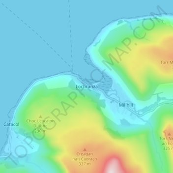
Name: Lochranza topographic map, elevation, terrain.
Location: Lochranza, North Ayrshire, Scotland, KA27 8HL, United Kingdom (55.68459 -5.31515 55.72459 -5.27515)
Average elevation: 325 ft
Minimum elevation: -7 ft
Maximum elevation: 1,591 ft
Thank you for supporting this site ❤️
Make a donation
Make a donation
Gear up for your next adventure:
As an Amazon Associate, this site earns from qualifying purchases at no extra cost to you.