Geolocate

Xiuning County topographic map

Click on the map to display elevation.

About this map

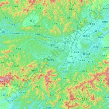
Name: Xiuning County topographic map, elevation, terrain.

Location: Xiuning County, Huangshan, Anhui, China (29.39523 117.64264 30.02704 118.43972)

Average elevation: 1,230 ft

Minimum elevation: 295 ft

Maximum elevation: 5,236 ft

Other topographic maps

Click on a map to view its topography, its elevation and its terrain.

Xidi

China > Anhui > Huangshan

Average elevation: 968 ft

Huangsan Village

China > Anhui > Huangshan

Average elevation: 1,401 ft

Gear up for your next adventure:

🪶Paracord Bracelet - Survival bracelet with built‑in tools
📡Handheld GPS Device - Reliable handheld GPS for outdoor navigation
🔥Plasma Lighters - Windproof lighters that work in any weather condition
GPS Sports Watch - GPS watch for running, hiking and training
⛑️Personal Locator Beacon - Safety beacon for emergencies

As an Amazon Associate, this site earns from qualifying purchases at no extra cost to you.