
Make a donation
Gear up for your next adventure:
As an Amazon Associate, this site earns from qualifying purchases at no extra cost to you.
Greenhow Hill topographic map
Click on the map to display elevation.
Make a donation
Gear up for your next adventure:
As an Amazon Associate, this site earns from qualifying purchases at no extra cost to you.
Greenhow Hill
The village is about 3 miles (4.8 km) west of Pateley Bridge on the road heading towards Grassington, and is mainly in the civil parish of Bewerley. However, the western end of the village lying to the west of Kell Dyke, commonly known as Craven Cross, lies within the civil parish of Appletreewick in Craven. It is one of the highest villages in Yorkshire, at an altitude of between 1,310 and 1,380 feet (400 and 420 m), and one of the few villages in the United Kingdom lying at over 1,300 feet (400 m).
Make a donation
Gear up for your next adventure:
As an Amazon Associate, this site earns from qualifying purchases at no extra cost to you.
About this map
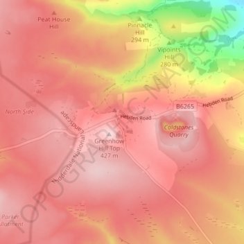
Name: Greenhow Hill topographic map, elevation, terrain.
Average elevation: 1,175 ft
Minimum elevation: 577 ft
Maximum elevation: 1,414 ft
Make a donation
Gear up for your next adventure:
As an Amazon Associate, this site earns from qualifying purchases at no extra cost to you.
Other topographic maps
Click on a map to view its topography, its elevation and its terrain.
Make a donation
Gear up for your next adventure:
As an Amazon Associate, this site earns from qualifying purchases at no extra cost to you.
Middleham
United Kingdom > England > North Yorkshire
The town lies between 400 and 500 feet (120 and 150 m) above ordnance datum. The valley of the River Ure below the town has an altitude of 325 feet (99 m) and the summit of the hill to the south-west of the town of 850 feet (260 m). The parish contains 2,155 acres (872 ha) of land, mostly permanent pasture…
Average elevation: 515 ft
Scarborough
United Kingdom > England > North Yorkshire > Scarborough
The climate is temperate with mild summers and cool, windy, winters. The hottest months of the year are July and August, with temperatures reaching an average high of 17 °C and falling to 11 °C at night. The average daytime temperatures in January are 4 °C, falling to 1 °C at night. The station's elevation…
Average elevation: 164 ft
Make a donation
Gear up for your next adventure:
As an Amazon Associate, this site earns from qualifying purchases at no extra cost to you.