
Make a donation
Gear up for your next adventure:
As an Amazon Associate, this site earns from qualifying purchases at no extra cost to you.
Cayenne topographic map
Click on the map to display elevation.
Make a donation
Gear up for your next adventure:
As an Amazon Associate, this site earns from qualifying purchases at no extra cost to you.
About this map
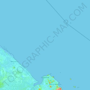
Name: Cayenne topographic map, elevation, terrain.
Location: Cayenne, French Guiana, 97300, France (4.88690 -52.59379 5.29727 -52.16250)
Average elevation: 3 ft
Minimum elevation: -3 ft
Maximum elevation: 554 ft
Make a donation
Gear up for your next adventure:
As an Amazon Associate, this site earns from qualifying purchases at no extra cost to you.
Other topographic maps
Click on a map to view its topography, its elevation and its terrain.
Make a donation
Gear up for your next adventure:
As an Amazon Associate, this site earns from qualifying purchases at no extra cost to you.
Make a donation
Gear up for your next adventure:
As an Amazon Associate, this site earns from qualifying purchases at no extra cost to you.
Saint-Laurent-du-Maroni
France > French Guiana > Saint-Laurent-du-Maroni > Saint-Laurent-du-Maroni
Average elevation: 30 ft