
Make a donation
Gear up for your next adventure:
As an Amazon Associate, this site earns from qualifying purchases at no extra cost to you.
Zwingenberg topographic map
Click on the map to display elevation.
Make a donation
Gear up for your next adventure:
As an Amazon Associate, this site earns from qualifying purchases at no extra cost to you.
Zwingenberg
Zwingenberg lies on the western edge of the Odenwald at the foot of the Melibokus, at 517.4 m above sea level the Bergstraße's highest mountain. The municipal area's elevation varies between roughly 90 m above sea level in the outlying centre of Rodau and just under 300 m on the slope of the Melibokus. Zwingenberg's highest elevation is no one single mountain. Rather, it runs along the Melibokus's slope into the area of Auerbach, an outlying centre of Bensheim. The 100-metre marker at Zwingenberg railway station is taken to be the standard. In the west, Zwingenberg abuts the Hessisches Ried, and thereby the Rhine rift.
Make a donation
Gear up for your next adventure:
As an Amazon Associate, this site earns from qualifying purchases at no extra cost to you.
About this map
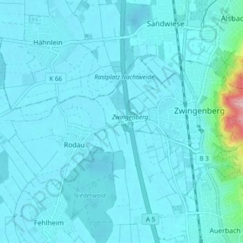
Name: Zwingenberg topographic map, elevation, terrain.
Location: Zwingenberg, Kreis Bergstraße, Hesse, 64673, Germany (49.71129 8.56049 49.73428 8.62693)
Average elevation: 341 ft
Minimum elevation: 292 ft
Maximum elevation: 928 ft
Make a donation
Gear up for your next adventure:
As an Amazon Associate, this site earns from qualifying purchases at no extra cost to you.
Other topographic maps
Click on a map to view its topography, its elevation and its terrain.
Wald-Michelbach
Germany > Hesse > Kreis Bergstraße > Wald-Michelbach > Wald-Michelbach
Average elevation: 1,299 ft