
Make a donation
Gear up for your next adventure:
As an Amazon Associate, this site earns from qualifying purchases at no extra cost to you.
Rio de Janeiro topographic map
Click on the map to display elevation.
Make a donation
Gear up for your next adventure:
As an Amazon Associate, this site earns from qualifying purchases at no extra cost to you.
Rio de Janeiro
The entire state is located within the tropics (the Tropic of Capricorn passes just a few kilometers south of the state's southernmost point) so a tropical climate is predominant. However, due to altitude, temperatures can drop to freezing point or below in some parts. Frost is not uncommon in some mountainous cities such as Teresópolis, Nova Friburgo and Petrópolis and snow has been reported occasionally in the Itatiaia National Park.
Make a donation
Gear up for your next adventure:
As an Amazon Associate, this site earns from qualifying purchases at no extra cost to you.
About this map
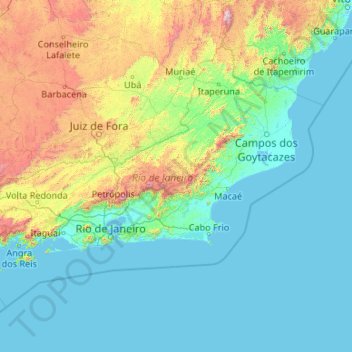
Name: Rio de Janeiro topographic map, elevation, terrain.
Location: Rio de Janeiro, Southeast Region, Brazil (-23.69269 -44.88932 -20.76321 -40.62963)
Average elevation: 1,047 ft
Minimum elevation: -7 ft
Maximum elevation: 9,019 ft
Make a donation
Gear up for your next adventure:
As an Amazon Associate, this site earns from qualifying purchases at no extra cost to you.
Other topographic maps
Click on a map to view its topography, its elevation and its terrain.
Atlantic Forest
Brazil > São Paulo > Região Metropolitana de São Paulo > Ribeirão Pires
Average elevation: 2,582 ft