Geolocate

Boot topographic map

Click on the map to display elevation.

About this map

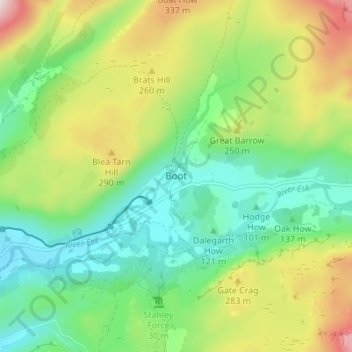
Name: Boot topographic map, elevation, terrain.

Location: Boot, Cumberland, England, CA19 1TG, United Kingdom (54.37841 -3.28954 54.41841 -3.24954)

Average elevation: 594 ft

Minimum elevation: 89 ft

Maximum elevation: 1,532 ft

Other topographic maps

Click on a map to view its topography, its elevation and its terrain.

Kirkfell Tarn

United Kingdom > England > Cumberland

Average elevation: 1,509 ft

Gear up for your next adventure:

🕶️GPS Smartphone Mount - Secure mount for phone navigation
Solar GPS Watches - Advanced multisport watches with built-in topographic maps
💧Water Purification System - Clean water on the trail with reliable purifiers
🩳Quick‑Dry Hiking Shorts - Comfortable and quick‑dry shorts for summer hiking
🏔️Mountain Trail Maps - High‑detail maps for popular peaks

As an Amazon Associate, this site earns from qualifying purchases at no extra cost to you.