
Thank you for supporting this site ❤️
Make a donation
Make a donation
Gear up for your next adventure:
As an Amazon Associate, this site earns from qualifying purchases at no extra cost to you.
Betzenrod topographic map
Click on the map to display elevation.
Thank you for supporting this site ❤️
Make a donation
Make a donation
Gear up for your next adventure:
As an Amazon Associate, this site earns from qualifying purchases at no extra cost to you.
About this map
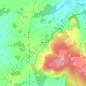
Name: Betzenrod topographic map, elevation, terrain.
Location: Betzenrod, Eiterfeld, Landkreis Fulda, Hessen, Deutschland (50.72442 9.75955 50.74121 9.78393)
Average elevation: 1,194 ft
Minimum elevation: 1,020 ft
Maximum elevation: 1,427 ft
Thank you for supporting this site ❤️
Make a donation
Make a donation
Gear up for your next adventure:
As an Amazon Associate, this site earns from qualifying purchases at no extra cost to you.
Other topographic maps
Click on a map to view its topography, its elevation and its terrain.