
Groet topographic map
Interactive map
Click on the map to display elevation.
About this map
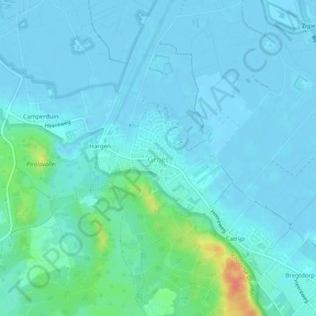
Name: Groet topographic map, elevation, terrain.
Location: Groet, Bergen, Noord-Holland, Nederland (52.71719 4.65941 52.72672 4.67962)
Average elevation: 23 ft
Minimum elevation: -10 ft
Maximum elevation: 144 ft
Other topographic maps
Click on a map to view its topography, its elevation and its terrain.
Bergen
Nederland > Noord-Holland > Bergen
Bergen, Noord-Holland, Nederland, 1861KB, Nederland
Average elevation: 10 ft
Bergen aan Zee
Nederland > Noord-Holland > Bergen
Bergen aan Zee, Bergen, Noord-Holland, Nederland
Average elevation: 20 ft
Egmond aan Zee
Nederland > Noord-Holland > Bergen
Egmond aan Zee, Bergen, Noord-Holland, Nederland
Average elevation: 23 ft
Groet
Nederland > Noord-Holland > Bergen > Groet
Groet, Bergen, Noord-Holland, Nederland, 1873, Nederland
Average elevation: 20 ft