
Make a donation
Gear up for your next adventure:
As an Amazon Associate, this site earns from qualifying purchases at no extra cost to you.
New Brighton topographic map
Click on the map to display elevation.
Make a donation
Gear up for your next adventure:
As an Amazon Associate, this site earns from qualifying purchases at no extra cost to you.
About this map
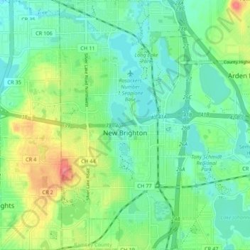
Name: New Brighton topographic map, elevation, terrain.
Location: New Brighton, Ramsey County, Minnesota, 55112, United States (45.03573 -93.22775 45.09359 -93.18263)
Average elevation: 925 ft
Minimum elevation: 853 ft
Maximum elevation: 1,086 ft
Ramsey County trails, hiking, mountain biking, running and outdoor activities
Make a donation
Gear up for your next adventure:
As an Amazon Associate, this site earns from qualifying purchases at no extra cost to you.
Other topographic maps
Click on a map to view its topography, its elevation and its terrain.
Make a donation
Gear up for your next adventure:
As an Amazon Associate, this site earns from qualifying purchases at no extra cost to you.
Ford Dam Scenic Overlook
United States > Minnesota > Ramsey County > Saint Paul
Average elevation: 823 ft