
Make a donation
Gear up for your next adventure:
As an Amazon Associate, this site earns from qualifying purchases at no extra cost to you.
Congosto topographic map
Click on the map to display elevation.
Make a donation
Gear up for your next adventure:
As an Amazon Associate, this site earns from qualifying purchases at no extra cost to you.
About this map
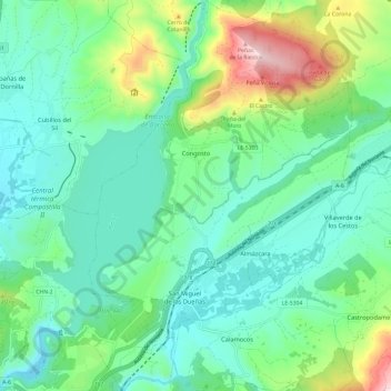
Name: Congosto topographic map, elevation, terrain.
Location: Congosto, El Bierzo, León, Castilië en León, Spanje (42.56448 -6.55275 42.65159 -6.47276)
Average elevation: 2,241 ft
Minimum elevation: 1,759 ft
Maximum elevation: 3,704 ft
Make a donation
Gear up for your next adventure:
As an Amazon Associate, this site earns from qualifying purchases at no extra cost to you.
Other topographic maps
Click on a map to view its topography, its elevation and its terrain.
El Puente de Domingo Flórez / A Ponte
Spanje > Castilië en León > El Bierzo > Puente de Domingo Flórez
Average elevation: 1,729 ft
Make a donation
Gear up for your next adventure:
As an Amazon Associate, this site earns from qualifying purchases at no extra cost to you.
Ponferrada
Spanje > Castilië en León > El Bierzo > Ponferrada > Ponferrada
Average elevation: 1,916 ft
Las Médulas
Spanje > Castilië en León > El Bierzo > Carucedo > Las Médulas
Average elevation: 2,451 ft
San Fiz do Seo
Spanje > Castilië en León > El Bierzo > Trabadelo > San Fiz do Seo
Average elevation: 2,566 ft