Geolocate

Chilham topographic map

Click on the map to display elevation.

About this map

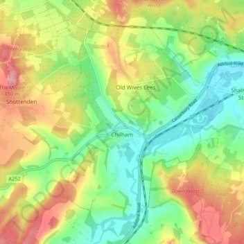
Name: Chilham topographic map, elevation, terrain.

Location: Chilham, Ashford, Kent, England, United Kingdom (51.22450 0.91674 51.27024 0.99821)

Average elevation: 240 ft

Minimum elevation: 52 ft

Maximum elevation: 482 ft

Other topographic maps

Click on a map to view its topography, its elevation and its terrain.

Hamstreet

United Kingdom > England > Kent > Ashford

Average elevation: 72 ft

Hinxhill

United Kingdom > England > Kent > Ashford

Average elevation: 167 ft

Gear up for your next adventure:

⛑️Personal Locator Beacon - Safety beacon for emergencies
GPS Sports Watch - GPS watch for running, hiking and training
📦Dry Bags Set - Waterproof storage for electronics and clothes
🛰️Satellite Messengers - Emergency SOS and two-way messaging for off-grid adventures
🪓Survival Multi‑Tool - Versatile tool for camp and trail tasks

As an Amazon Associate, this site earns from qualifying purchases at no extra cost to you.