Geolocate

Dewetsdorp topographic map

Click on the map to display elevation.

About this map

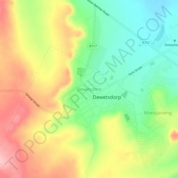
Name: Dewetsdorp topographic map, elevation, terrain.

Location: Dewetsdorp, Naledi Local Municipality, Xhariep District Municipality, Free State, South Africa (-29.60122 26.64460 -29.56122 26.68460)

Average elevation: 5,138 ft

Minimum elevation: 4,902 ft

Maximum elevation: 5,417 ft

Other topographic maps

Click on a map to view its topography, its elevation and its terrain.

Gear up for your next adventure:

🧦Merino Wool Socks - Moisture-wicking, blister-preventing socks for long treks
🧯Portable Fire Pit - Compact fire pit for camping spots
🚪Portable Camp Chair - Foldable chair for comfort at camp
🔥Plasma Lighters - Windproof lighters that work in any weather condition
🪶Trail Camera - Capture wildlife on your hikes

As an Amazon Associate, this site earns from qualifying purchases at no extra cost to you.