Geolocate

Paddock Wood topographic map

Click on the map to display elevation.

About this map

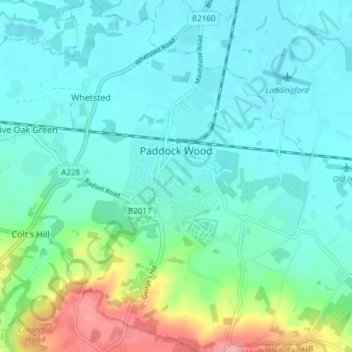
Name: Paddock Wood topographic map, elevation, terrain.

Location: Paddock Wood, Tunbridge Wells, Kent, England, United Kingdom (51.16053 0.36192 51.19461 0.43734)

Average elevation: 108 ft

Minimum elevation: 33 ft

Maximum elevation: 384 ft

Other topographic maps

Click on a map to view its topography, its elevation and its terrain.

Sissinghurst

United Kingdom > England > Kent > Tunbridge Wells

Average elevation: 217 ft

Gear up for your next adventure:

🪶Compact Camp Shovel - Folding shovel for campsite tasks
📡GPS Antenna Upgrade - Enhance GPS reception in remote terrain
🎒Day Hiking Backpack - Lightweight backpack perfect for day trips and outdoor adventures
Camping Coffee Makers - Enjoy premium coffee at the summit or campsite
🕶️Glacier Sunglasses - Side shields to protect eyes from high-altitude snow glare

As an Amazon Associate, this site earns from qualifying purchases at no extra cost to you.