Geolocate

Tribuana topographic map

Click on the map to display elevation.

About this map

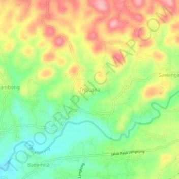
Name: Tribuana topographic map, elevation, terrain.

Location: Tribuana, Banjarnegara, Central Java, Java, 53462, Indonesia (-7.40070 109.55007 -7.36070 109.59007)

Average elevation: 669 ft

Minimum elevation: 430 ft

Maximum elevation: 945 ft

Other topographic maps

Click on a map to view its topography, its elevation and its terrain.

Kali Sapi

Indonesia > Central Java > Banjarnegara > Merden

Average elevation: 551 ft

Gear up for your next adventure:

🧣Hiking Neck Gaiter - Multi‑use neck protection for outdoor weather
🧷Carabiner Set - Durable clips for gear attachment
🚗GPS Dash Cams - Record your scenic drives through mountain passes and canyons
📷Action Camera - Capture your outdoor adventures in HD
📱Solar Portable Charger - Solar power bank for charging devices off‑grid

As an Amazon Associate, this site earns from qualifying purchases at no extra cost to you.